Abu Abd Allah Abdullah Muhammed ibn Muhammed ibn Ash Sharif al Idrīsī (or Edrisi) was born in Sabtah (now Ceuta), Morocco, around 1100.
He descended through a long line of distinguished and aristocratic personages from the Muslim prophet, Muhammed. He was a geographer, writer, scientist, cartographer and an adviser to Roger II, the Norman king of Sicily.
His immediate ancestors were the Hammudids of the caliphate of Spain and North Africa, a branch of Morocco’s Idrisids, and it was at Cordoba and Marrakesh that Idrīsī’s earliest education took place. Apparently his travels took him to many parts of western Europe, including Portugal, northern Spain, the French Atlantic coast and southern England. He visited Asia Minor when he was barely 16 years old.
RELATED STORIES


According to the contemporary Spanish Arab traveller Ibn Jubayr (1145-1217), Idrīsī’s Hammudi family was influential among Sicily’s Muslims, and his fame as a man of letters was known before his invitation to the court of King Roger II. He arrived in Sicily around 1145, and may have first visited as early as 1139. Idrīsī produced a number of works based on astute scholarly research, and it has been observed by modern Arabic scholars that Idrisi was an exceptional poet and writer of Arabic prose.
He lived and worked for the rest of his life at the court of King Roger II. Some Western scholars have suggested that al-Idrīsī may have been regarded as a renegade by other Muslims for entering the service of a Christian king. Upon agreeing to stay, Roger settled upon him a king’s pension.
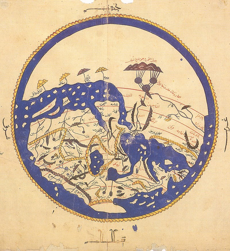
His famous planisphere, a large global map made of precious metal (mostly silver), did not survive the 12th century, but it is known to have been a noteworthy work of geography – probably the most accurate map of Europe, North Africa and Western Asia to have been created during the Middle Ages.
His greatest surviving work also regarded as one of the greatest works of medieval geography is the Kitāb nuzhat al-mushtāq fī ikhtirāq al-āfāq “Pleasure Excursion of One Eager to Traverse the World’s Regions,” better known as the Book of Roger.
In a casual observation, Idrīsī mentions the making of spaghetti in Trabia. It is to Idrīsī that we owe much of our knowledge of the entire Mediterranean. Some of the book’s statements were revolutionary for their time, things like “the earth is round like a sphere.” Today, the Book of Roger is considered one of the most important scientific works of the Middle Ages. That was not always the case among Europeans. Praised by Sicily’s Muslims, Jews and Orthodox (“Eastern”) Christians, the work was not generally appreciated by the medieval popes or the Roman Catholic clergy, and for that reason its knowledge was sometimes suppressed in Western Europe.
The Book of Roger was completed early in 1154, shortly before the death of the king for whom it was named. However, King Roger II’s son, William II, renewed al-Idrisi’s contract, so he could continue working for Sicily, where he spent the rest of his days.

“Al-Idrīsī’s service in Sicily resulted in the completion of three major geographic works: (1) a silver planisphere on which was depicted a map of the world, (2) a world map consisting of 70 sections formed by dividing the Earth north of the Equator into 7 climatic zones of equal width, each of which was subdivided into 10 equal parts by lines of longitude, and (3) a geographic text intended as a key to the planisphere. This was his great work of descriptive geography, known as Kitāb nuzhat al-mushtāq fī ikhtirāq al-āfāq and also as Kitā Rujār, or Al-Kitāb ar-Rujārī (“The Book of Roger”). In compiling it, al-Idrīsī combined material from Arabic and Greek geographic works with information obtained through firsthand observation and eyewitness reports. The king and his Arab geographer chose a number of persons, including men skilled in drawing, and dispatched them to various countries to observe and record what they saw. Al-Idrīsī completed the book in January 1154, shortly before Roger’s death.”
His Kitāb al-adwiya al-mufradah (“Book of Simple Drugs”), in which he lists the names of drugs in as many as 12 languages, demonstrates the range of his linguistic abilities.

On the geographical work of al-Idrīsī S.P. Scott wrote in 1904:
“The compilation of al-Idrīsī marks an era in the history of science. Not only is its historical information most interesting and valuable, but its descriptions of many parts of the earth are still authoritative. For three centuries geographers copied his maps without alteration. The relative position of the lakes which form the Nile, as delineated in his work, does not differ greatly from that established by Baker and Stanley more than seven hundred years afterwards, and their number is the same. The mechanical genius of the author was not inferior to his erudition. The celestial and terrestrial planisphere of silver which he constructed for his royal patron was nearly six feet in diameter, and weighed four hundred and fifty pounds; upon the one side the zodiac and the constellations, upon the other-divided for convenience into segments-the bodies of land and water, with the respective situations of the various countries, were engraved.”
Abdullah al-Idrīsī died around 1166, either in Sicily or in Morocco.